Queen Charlotte Track In Marlborough Sounds
Meretoto / Ship Cove to Endeavour Inlet 15 kms (5 hrs)
Endeavour Inlet to Camp Bay 11.5 kms (4 hrs)
Camp Bay to Torea Saddle 23 kms (8 hrs)
Torea Saddle to Mistletoe Bay 8 kms (4 hrs)
Mistletoe Bay to Anakiwa 12.5kms (4 hrs)
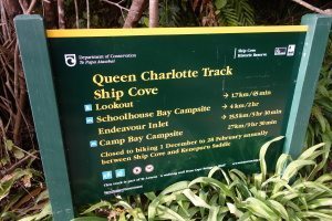 In the 1770s Captain James Cook visited Ship Cove – now the start of the Queen Charlotte Track, one of New Zealand’s Great Walks – and his encounters with the local Maori at the time are well-documented in his diaries. Even today, Ship Cove is still one of the least developed, and most pristine, monuments to Cook in the world. It is a fitting beginning to your journey.
Today the track, located in the Marlborough Sounds travels over a variety of public and private land. It is due to the goodwill of the private landowners that the single track can be created, and we encourage all users to respect the fact that at times they are walking on private land.
The Queen Charlotte Track is 71km long. It is normally walked in four or five days, starting at Ship Cove and finishing at Anakiwa. However, there are plenty of options to walk one section of the track in one day.
The track surface is predominantly clay-based, with tree roots and rocks traversing the surface at times. During wet weather it can be slippy, and we recommend that people walk with walking poles if they have joint weaknesses. During dry weather it is quite possible to walk the track in runners – however, we do recommend that you wear good walking shoes.
 Ship Cove to Endeavour Inlet
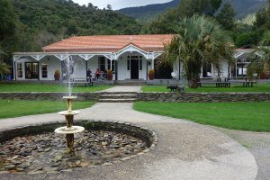
You will need to take a boat to Ship Cove to begin your walk as there is no road access. Once you arrive at Ship Cove, you can enjoy spending a short time exploring the historic site and interpretation panels.
The track begin with a climb away from the beach, and after 5o minutes walking you reach a lookout point at a saddle, where you’ll find excellent views of the Queen Charlotte Sound. Past the saddle, the track drops down to resolution Bay, where you’ll find a DOC campsite at Schoolhouse Bay and a little further along, private cabin accommodation.
From Resolution Bay the path heads along a well-graded bridle path over a ridge and into Endeavour Inlet. Winding down it runs along the shoreline to the head of the Inlet.
 Endeavour Inlet to Camp Bay
 Endeavour Inlet to Camp Bay
This section of the track remains close to the shoreline and meanders through native forest before rounding Big Bay to Camp Bay and the DOC campsite. Continuing on a short way, you will come to the private cabin accommodation.
Camp Bay to Torea Saddle
This section of the track is the longest and most strenuous section of the track, but well worth it for the magnifiscent views once you reach the top of the ridge.
From Camp Bay, head out to Kenepuru Saddle and walk along the ridge. Above Bay of Many Coves and Kumutoto Bay are two DOC campsites, both with toilets, water and a cooking shelter.
Eventually the track winds downwards to Totea Saddle between Portage and Torea Bay, where you’ll find the private cabin accommodation and DOC campsite.
Torea Saddle to Mistletoe Bay
Again, following the ridgeline, the track passes through gorse and maunaka bushland and a side walk that leads to a lookout shortly before the descent to Te Mahia Saddle.
On arrival at Mistletoe bay you’ll find Ca DOC campsite, and prive cabins.
Mistletoe bay to Anakiwa
This final section of the track begins up on the road above Mistletoe Bay and follows an old bridelpath high above the water. Rounding a point, it descends down to the DOC campsite at Davies Bay. The last hours walking is an easy and pleasant path through Beech trees on to Anakiwa.
Anikawa has a tolilet and telephone and a jetty from where you can catch a bost to Picton or spend the night in nearby accommodation.